Drone aerial imagery services
All in motion or frozen in time, a look whose perspective fascinates
Technical
inspection
Infrared
thermography
Planning &
Site supervision
Assessment
post-disaster
Technical inspection by drone in all its aspects
At first glance, most structures or buildings do not show any anomalies, but a non-invasive technical inspection by drone can reveal flaws…
To make sure you understand everything, it is important to observe them from all angles, even in places that are difficult to access. It is undeniable that the images captured by our drones will ensure that nothing is missed.
Technical inspection by drone now makes it possible to avoid the intervention of more expensive means such as scaffolding, cranes, nacelles or others. The drone will then provide rapid and precise visual inspection for infrastructure, roofs and building facades, exterior and interior sites that are difficult to access and complex structures such as bridges, viaducts, dams, etc.
Indeed, whether it is standard imaging in the visible spectrum or thermography, we are at your service to offer you complete coverage while having a good risk management methodology.
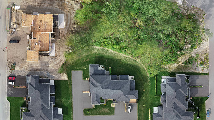
Effective mapping in your projects for before, during and after
S.T.A.N.D now offers a safer, faster and more cost-effective way to streamline your operations. Whether to generate a plan, a 3D digital twin, an orthophoto or a point cloud, 3D GIS data collection by drone allows you to model sites to help you make critical decisions in your business activities.
Modeling from 3D GIS data collection further simplifies the process. In particular, engineers, project managers and superintendents use it in their planning, mobilization and monitoring on large civil or building construction sites. It also allows you to perform volume calculations and share these elements with colleagues. This way, it is possible to compare, analyze and monitor them.


Reveal the invisible with our thermal drone imaging
Drone thermography is a cutting-edge technology that provides precise thermal images of buildings, industrial facilities, power lines, solar panels and much more. This method is very useful for identifying energy losses, water leaks, overheating areas and hidden faults that are not detectable with the naked eye.
S.T.A.N.D. offers drone thermography services that can provide rapid and accurate analysis of thermal anomalies, helping to reduce downtime and maintenance costs.
Our trained professionals use drones equipped with high-resolution thermal cameras to capture precise images of your facilities, reducing downtime and maintenance costs. Contact us now to learn more about our drone thermography services and how they can benefit your business.
Our post-disaster imaging for rapid and accurate damage assessment
Whether it is to map a sector which has just been recently developed, to report the situation during a disaster, a natural or environmental disaster, or to reconstruct an accident scene, the public safety drone comes both in helping municipalities during the normal course of activities and in times of crisis.
The precise acquisition of data and the speed with which it is processed and then disseminated amply justify the use of drones. In this regard, you can use it on multiple occasions and in various contexts.
We provided assistance to municipalities during the spring flood of 2019. In order to understand the extent of the damage following the overflowing of rivers, we captured the images.
Aerial shots covering the site from several angles facilitated the implementation of an intervention plan. To this end, public safety drones have made it possible to avoid further deterioration of weakened infrastructure.


Anything worth doing, deserves to be done well
Our SATP operators being considered by the Canadian Aviation Regulations as pilots in the same way as those flying on board their aircraft, have the assurance that each flight will be carried out in compliance with aeronautical laws to ensure safety. safety of any person on the ground and in flight. Aerial imaging by drone also requires serious and rigorous flight preparation even at low altitude.
Knowledge of the air class in which the aircraft operates with the required skills and required authorizations or the weather forecast of wind, temperature, precipitation versus the capabilities and limitations established by the manufacturer of the remotely piloted aircraft are just a few -one of the many checks that must be taken into account in order to carry out each flight safely.